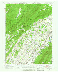
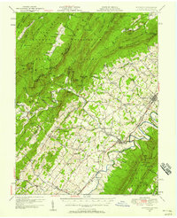
1947 Map of Edinburg
USGS Topo · Published 1966About this map
The North Fork Shenandoah River winds through the heart of the Shenandoah Valley, paralleling the Southern Railway and the Lee Highway. This post-war survey highlights a landscape of well-established valley towns like Edinburg, Woodstock, and Mt Jackson, while the western slopes of Long Mountain and Supin Mountain reveal a legacy of early industry. The presence of Van Buren Furnace, Columbia Furnace, and Liberty Furnace speaks to the iron production that once defined these foothills within the George Washington National Forest.
Find a feature on this map
113 named features on this map. Tap any name to fly to it.
Don’t see what you’re looking for? This feature index may not catch every label — zoom into the map to look around manually.
Map Details
Editions of this 1947 Edinburg Map
2 editions found
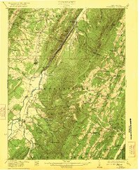
Other maps of this area

1891 · Romney
USGS Topo · 1:125,000

1892 · Woodstock
USGS Topo · 1:125,000

1893 · Luray
USGS Topo · 1:125,000

1894 · Winchester
USGS Topo · 1:125,000

1905 · Luray
USGS Topo · 1:125,000

1920 · Moorefield
USGS Topo · 1:62,500

1921 · Orkney Springs
USGS Topo · 1:48,000

1921 · Moorefield
USGS Topo · 1:48,000
1922 · Moorefield
USGS Topo · 1:62,500

1922 · Wardensville
USGS Topo · 1:62,500