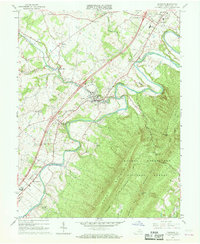
1966 Map of Edinburg
USGS Topo · Published 1968About this map
The North Fork Shenandoah River carves the dramatic, serpentine loops of the Seven Bends across this 1960s Shenandoah Valley landscape. This survey documents a critical period of infrastructure growth, capturing the Southern railroad line and new highway interchanges alongside established community hubs like Edinburg and Lantz Mills. On the eastern horizon, the massive ridgeline of Massanutten Mountain rises within the George Washington National Forest, punctuated by Waonaze Peak and the Edinburg Gap. Local heritage is well-preserved through numerous rural landmarks, including Massanutten Military Academy and a network of country houses of worship such as Wakemans Grove Ch and Wesley Chapel. The map effectively illustrates the transition from traditional river-valley agriculture to a modernizing corridor, evidenced by the proximity of the Edinburg Reservoir and local industry like the Gravel Pit.
Find a feature on this map
41 named features on this map. Tap any name to fly to it.
Don’t see what you’re looking for? This feature index may not catch every label — zoom into the map to look around manually.
Map Details
Editions of this 1966 Edinburg Map
Other maps of this area

1892 · Woodstock
USGS Topo · 1:125,000

1893 · Luray
USGS Topo · 1:125,000

1905 · Luray
USGS Topo · 1:125,000

1923 · Edinburg
USGS Topo · 1:62,500

1929 · Stony Man
USGS Topo · 1:48,000

1933 · Stony Man
USGS Topo · 1:62,500

1942 · Mt Jackson
USGS Topo · 1:62,500

1946 · Mt Jackson
USGS Topo · 1:62,500

1947 · Mt Jackson
USGS Topo · 1:62,500

1947 · Strasburg
USGS Topo · 1:62,500