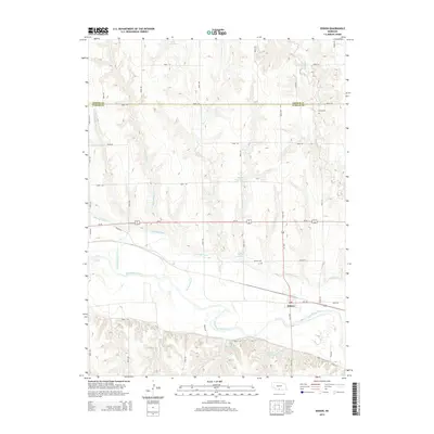
2014 Map of Edison
USGS Topo · Published 2014About this map
The Republican River valley defines the character of this Furnas County landscape, where the small settlement of Edison sits at the junction of Us-34 and Us-136. This agricultural region is heavily defined by its water management systems, notably the Cambridge Canal which skirts the northern banks of the river. The topography is marked by numerous creeks such as Big Antelope Cr and Turkey Cr feeding into the main river channel, with several family-named water bodies including Gregg Reservoir, Ziebell Reservoir, and Broeker Reservoir punctuating the uplands. Local history is anchored by the Edison Cem and the Stump Cem, the latter located near the border with Gosper County. The map provides a clear view of the rural section-line road network, such as Road 726 and Road 430, which have organized the prairie into its modern agricultural layout.
Find a feature on this map
33 named features on this map. Tap any name to fly to it.
Don’t see what you’re looking for? This feature index may not catch every label — zoom into the map to look around manually.
Map Details
Editions of this 2014 Edison Map
This is the sole edition of this map. No revisions or reprints were ever made.
Other maps of this area

1896 · Arapahoe
USGS Topo · 1:125,000

1898 · Arapahoe
USGS Topo · 1:125,000

1955 · Grand Island
USGS Topo · 1:250,000

1957 · Grand Island
USGS Topo · 1:250,000

1958 · Grand Island
USGS Topo · 1:250,000

1958 · Edison
USGS Topo · 1:24,000

1958 · Hollinger
USGS Topo · 1:24,000
1958 · Arapahoe
USGS Topo · 1:24,000
1958 · Hendley
USGS Topo · 1:24,000
1958 · Beaver City
USGS Topo · 1:24,000