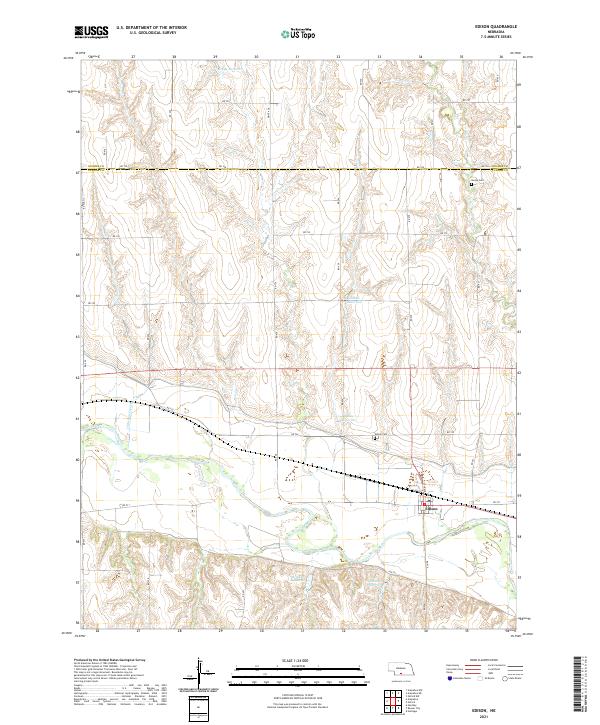
2021 Map of Edison
USGS Topo · Published 2021About this map
Edison anchors the southern portion of this landscape, situated near the boundary where the undulating uplands meet the broader drainage of the Republican River valley. The village layout is defined by Main St and the local Po, serving as a central hub for the surrounding agricultural sections. The map reveals a distinct pattern of water management across the Furnas and Gosper county line, with several named impoundments including Gregg Reservoir, Ziebell Reservoir, and Paine Reservoir distributed through the northern draws. These reservoirs, alongside Broeker Reservoir and Lueking Reservoir to the south, highlight the region's reliance on managed water resources for ranching and farming. Local history and genealogy are well-represented by rural burial grounds like Edison Cem and Stump Cem, which remain tucked away on section lines far from the primary settlement. The terrain is further etched by the paths of Little Antelope Cr and Crum Cr, which carve through the high plains topography.
Find a feature on this map
30 named features on this map. Tap any name to fly to it.
Don’t see what you’re looking for? This feature index may not catch every label — zoom into the map to look around manually.
Map Details
Editions of this 2021 Edison Map
This is the sole edition of this map. No revisions or reprints were ever made.
Other maps of this area

1896 · Arapahoe
USGS Topo · 1:125,000

1898 · Arapahoe
USGS Topo · 1:125,000

1955 · Grand Island
USGS Topo · 1:250,000

1957 · Grand Island
USGS Topo · 1:250,000

1958 · Grand Island
USGS Topo · 1:250,000

1958 · Edison
USGS Topo · 1:24,000

1958 · Hollinger
USGS Topo · 1:24,000
1958 · Arapahoe
USGS Topo · 1:24,000
1958 · Hendley
USGS Topo · 1:24,000
1958 · Beaver City
USGS Topo · 1:24,000