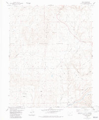
1984 Map of Edith
USGS Topo · Published 1984About this map
Edith sits at the southern edge of this 1984 survey, positioned where the Navajo River crosses the border between New Mexico and Colorado. The terrain is defined by high plateaus and complex drainage systems, featuring landmarks like Archuleta Mesa and Mesa Del Medio. An Old Railroad Grade winds through the northern section, tracing a path past Halfway and through the San Juan National Forest, indicating former industrial or transit corridors through the timberlands. Along the river valley, evidence of local resource management appears through the Shahan Ditch and a Gaging Sta. The map also captures the boundary of the Jicarilla Indian Reservation as it meets Archuleta and Rio Arriba Counties, providing a clear look at the intersection of tribal, county, and state lands in the late twentieth century.
Find a feature on this map
38 named features on this map. Tap any name to fly to it.
Don’t see what you’re looking for? This feature index may not catch every label — zoom into the map to look around manually.
Map Details
Editions of this 1984 Edith Map
2 editions found
Other maps of this area

1889 · Largo
USGS Topo · 1:250,000

1895 · Largo
USGS Topo · 1:250,000

1913 · Summitville
USGS Topo · 1:125,000

1915 · Summitville
USGS Topo · 1:125,000

1924 · Pagosa Springs
USGS Topo · 1:125,000

1927 · Pagosa Springs
USGS Topo · 1:125,000

1945 · Durango
USGS Topo · 1:250,000

1953 · Durango
USGS Topo · 1:250,000

1954 · Durango
USGS Topo · 1:250,000

1954 · Aztec
USGS Topo · 1:250,000