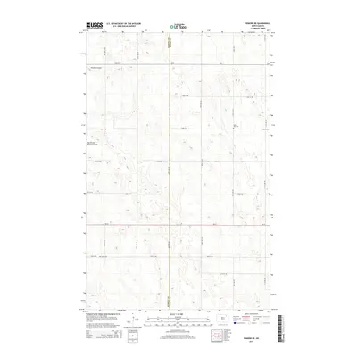
2014 Map of Edmore NE
USGS Topo · Published 2014About this map
The rolling plains along the border of Ramsey Co and Walsh Co are defined by a rhythmic grid of rural roads and the subtle depressions of North Dakota coulees. Nekoma Coulee and its East Branch provide the primary drainage for this agricultural landscape, carving gentle paths through the terrain. Evidence of the area's early settlement persists in the form of two remote burial grounds: Saint Olaf Cem in the northeastern section and Sobak Cem to the southwest. The presence of ND-17 and CR-9 provides the modern framework for this section of the Red River Valley upland, where the section-line roads like 110th Ave NE trace the orderly distribution of land established over a century ago.
Find a feature on this map
20 named features on this map. Tap any name to fly to it.
Don’t see what you’re looking for? This feature index may not catch every label — zoom into the map to look around manually.
Map Details
Editions of this 2014 Edmore NE Map
This is the sole edition of this map. No revisions or reprints were ever made.
Other maps of this area
1953 · Devils Lake
USGS Topo · 1:250,000
1956 · Devils Lake
USGS Topo · 1:250,000
1972 · Edmore SW
USGS Topo · 1:24,000
1972 · Nekoma
USGS Topo · 1:24,000
1972 · Osnabrock SW
USGS Topo · 1:24,000
1972 · Edmore
USGS Topo · 1:24,000
1972 · Adams SW
USGS Topo · 1:24,000
1972 · Fairdale
USGS Topo · 1:24,000
1972 · Edmore NE
USGS Topo · 1:24,000
1972 · Billings Lake
USGS Topo · 1:24,000