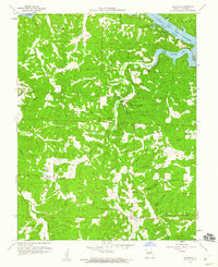
1959 Map of Edwards
USGS Topo · Published 1960About this map
Deer Creek and Turkey Creek carve through the steep topography of southern Benton County, feeding the northern reaches of the Lake of the Ozarks. This 1959 revision reflects a landscape where upland ridges like Miller Ridge separate deep hollows named for early families and local landmarks, including Hunter Hollow and Sawmill Hollow. The settlement at Edwards and the small hamlet of Hastam serve as focal points for a rural community connected by unimproved roads and light-duty routes. Genealogists will find notable value in the location of the Short School and local burial grounds such as Belleview Cem and Hastam Cem. The map illustrates the shoreline of the Deer Creek Arm and Duroc Bay, showing how the impounded river system integrated with the existing creek valleys of Union and F R I S T O E townships.
Find a feature on this map
36 named features on this map. Tap any name to fly to it.
Don’t see what you’re looking for? This feature index may not catch every label — zoom into the map to look around manually.
Map Details
Editions of this 1959 Edwards Map
2 editions found
Other maps of this area

1887 · Warsaw
USGS Topo · 1:125,000

1894 · Warsaw
USGS Topo · 1:125,000

1935 · Edwards
USGS Topo · 1:24,000

1935 · Dell
USGS Topo · 1:24,000

1935 · Boylers Mill
USGS Topo · 1:24,000

1935 · Knobby Creek
USGS Topo · 1:24,000

1936 · Lakeview Heights
USGS Topo · 1:24,000

1936 · Schuyler
USGS Topo · 1:24,000

1945 · Fristoe
USGS Topo · 1:62,500

1947 · Jefferson City
USGS Topo · 1:250,000