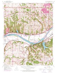
1950 Map of Edwardsville
USGS Topo · Published 1971About this map
Edwardsville sits at the center of this 1950 revision, overlooking the Kansas River where the Union Pacific line follows the northern bank. The landscape shows a deep network of rural institutions, from the County Home and Agriculture Hall of Fame to numerous country schools like Timmons Sch and Round Prairie Sch. To the south, the Atchison Topeka and Santa Fe railroad cuts through Wilder and Holiday, following the curves of Mill Creek. A significant transition is visible through purple photorevision overlays from 1970, which track the expansion of residential footprints near Grinter Heights and Stony Point, as well as the development surrounding Quivira Lake. These updates provide a rare side-by-side comparison of the post-war landscape and the encroaching suburbanization of the Kansas City periphery.
Find a feature on this map
48 named features on this map. Tap any name to fly to it.
Don’t see what you’re looking for? This feature index may not catch every label — zoom into the map to look around manually.
Map Details
Editions of this 1950 Edwardsville Map
3 editions found
Other maps of this area

1887 · Olathe
USGS Topo · 1:125,000

1890 · Kansas City
USGS Topo · 1:125,000

1893 · Olathe
USGS Topo · 1:125,000

1894 · Kansas City
USGS Topo · 1:125,000

1934 · Bonner Springs
USGS Topo · 1:48,000

1934 · Shawnee
USGS Topo · 1:24,000

1934 · Edwardsville
USGS Topo · 1:24,000

1934 · Wolcott
USGS Topo · 1:24,000

1935 · Olathe
USGS Topo · 1:24,000

1935 · Lenexa
USGS Topo · 1:24,000