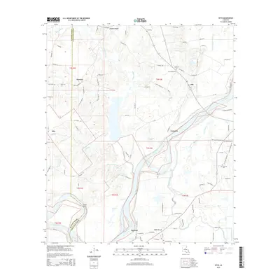
2015 Map of Effie
USGS Topo · Published 2015About this map
The Red River snakes through the heart of this landscape, defining the boundary and commerce of Avoyelles and Rapides Parishes. The river's influence is seen in the sweeping meander of Egg Bend and the high ground of Grimes Bluff, while the surrounding lowlands are crisscrossed by a complex drainage network including Wiggins Bayou, Gin Bayou, and Bayou Choctaw. In this corner of Louisiana, the settlement pattern is dispersed, with small communities like Center Point, Fifth Ward, and Cassandra linked by a web of local roads such as Wiggins Rd and La-454. For those looking into family history, the map identifies several local burial grounds, including French Cem, Oak Grove Cem, and Saint Catherine Cem. The coexistence of natural water bodies like Gin Lake and Bordelon Lake alongside infrastructure like the United Gas Ln illustrates the mix of traditional bayou terrain and modern energy transit.
Find a feature on this map
97 named features on this map. Tap any name to fly to it.
Don’t see what you’re looking for? This feature index may not catch every label — zoom into the map to look around manually.
Map Details
Editions of this 2015 Effie Map
This is the sole edition of this map. No revisions or reprints were ever made.
Other maps of this area

1935 · Lecompte
USGS Topo · 1:62,500

1940 · Marksville
USGS Topo · 1:62,500

1941 · Alexandria
USGS Topo · 1:62,500

1941 · Buckeye
USGS Topo · 1:62,500

1953 · Alexandria
USGS Topo · 1:250,000

1955 · Alexandria
USGS Topo · 1:250,000

1957 · Alexandria
USGS Topo · 1:62,500

1957 · Lecompte
USGS Topo · 1:62,500

1959 · Buckeye
USGS Topo · 1:62,500
1962 · Marksville
USGS Topo · 1:62,500