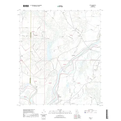
2018 Map of Effie
USGS Topo · Published 2018About this map
Effie and Reynolds sit atop the rising terrace lands of eastern Avoyelles Parish, where the elevation drops into the complex bottomlands of the Red River. This 2018 survey reveals a landscape defined by its proximity to water, with an intricate network of waterways including Wiggins Bayou, Bayou Prairie, and Bayou Choctaw weaving through the lower elevations. The map provides significant detail for local historians, marking numerous family-named landmarks and rural burial sites such as Saint Catherine Cemetery and Oak Grove Cemetery. Settlements like Cassandra and Egg Bend are linked by a grid of local connectors, including River Road and Cardinal Loop Road, reflecting a long-established pattern of river-adjacent habitation. The presence of Bordelon Lake and Gin Lake further emphasizes the oxbow and backwater geography characteristic of this segment of the Red River valley.
Find a feature on this map
78 named features on this map. Tap any name to fly to it.
Don’t see what you’re looking for? This feature index may not catch every label — zoom into the map to look around manually.
Map Details
Editions of this 2018 Effie Map
This is the sole edition of this map. No revisions or reprints were ever made.
Other maps of this area

1935 · Lecompte
USGS Topo · 1:62,500

1940 · Marksville
USGS Topo · 1:62,500

1941 · Alexandria
USGS Topo · 1:62,500

1941 · Buckeye
USGS Topo · 1:62,500

1953 · Alexandria
USGS Topo · 1:250,000

1955 · Alexandria
USGS Topo · 1:250,000

1957 · Alexandria
USGS Topo · 1:62,500

1957 · Lecompte
USGS Topo · 1:62,500

1959 · Buckeye
USGS Topo · 1:62,500
1962 · Marksville
USGS Topo · 1:62,500