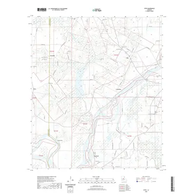
2020 Map of Effie
USGS Topo · Published 2020About this map
Effie and its surrounding communities sit within the intricate hydrography of Avoyelles Parish, where the winding course of the Red River dominates the landscape. The map reveals a complex system of bayous and wetlands, including the broad reaches of Cassandra and the southern settlement at Egg Bend. This 2020 survey illustrates how the local road network navigates the low-lying terrain, connecting small clusters of habitation like Reynolds and Ruby to the water-bound interior. The drainage patterns of the various bayous shown here underscore the historical importance of water management and river-based transport in this part of Louisiana, providing a modern record of land use and settlement in a region defined by its alluvial geography.
Find a feature on this map
5 named features on this map. Tap any name to fly to it.
Don’t see what you’re looking for? This feature index may not catch every label — zoom into the map to look around manually.
Map Details
Editions of this 2020 Effie Map
This is the sole edition of this map. No revisions or reprints were ever made.
Other maps of this area

1935 · Lecompte
USGS Topo · 1:62,500

1940 · Marksville
USGS Topo · 1:62,500

1941 · Alexandria
USGS Topo · 1:62,500

1941 · Buckeye
USGS Topo · 1:62,500

1953 · Alexandria
USGS Topo · 1:250,000

1955 · Alexandria
USGS Topo · 1:250,000

1957 · Alexandria
USGS Topo · 1:62,500

1957 · Lecompte
USGS Topo · 1:62,500

1959 · Buckeye
USGS Topo · 1:62,500
1962 · Marksville
USGS Topo · 1:62,500