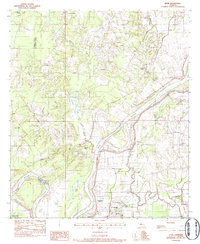
1983 Map of Effie
USGS Topo · Published 1983About this map
The Red River winds through the heart of the central Louisiana lowlands, creating a landscape defined by oxbow lakes and meandering bayous. This early 1980s document reveals a network of small rural settlements including Effie, Fifth Ward, and Center Point, where local life centered around country churches and schools. The placement of Our Lady of Lourdes Ch and St Winifred Ch alongside family burial grounds like Pierce Cem provides significant data for genealogists tracking local ancestry in the parish. The map captures the transitional period of the regional economy, where water bodies such as Bordelon Lake and Gin Lake sit adjacent to Rays Landing Strip. The boundary between Rapides Parish and Avoyelles Parish follows the natural watercourses, illustrating how the swampy terrain of Wiggins Bayou and Prairie Bayou dictated historical political borders.
Find a feature on this map
32 named features on this map. Tap any name to fly to it.
Don’t see what you’re looking for? This feature index may not catch every label — zoom into the map to look around manually.
Map Details
Editions of this 1983 Effie Map
This is the sole edition of this map. No revisions or reprints were ever made.
Other maps of this area

1935 · Lecompte
USGS Topo · 1:62,500

1940 · Marksville
USGS Topo · 1:62,500

1941 · Alexandria
USGS Topo · 1:62,500

1941 · Buckeye
USGS Topo · 1:62,500

1953 · Alexandria
USGS Topo · 1:250,000

1955 · Alexandria
USGS Topo · 1:250,000

1957 · Alexandria
USGS Topo · 1:62,500

1957 · Lecompte
USGS Topo · 1:62,500

1959 · Buckeye
USGS Topo · 1:62,500
1962 · Marksville
USGS Topo · 1:62,500