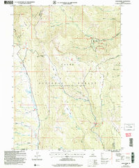
2005 Map of Egan Basin
USGS Topo · Published 2007About this map
The high ridges of the Bear Lake Range dominate this Idaho-Utah borderlands survey, where the Cache National Forest is managed under the administration of the Caribou National Forest. High-altitude hydrology is a central theme, with drainages like St Charles Creek and the Logan River carving through the limestone terrain. Notable landmarks include the subterranean complex of Minnetonka Cave and high-basin water bodies such as Blue Lake, Hidden Lake, and Wiggler Lake. The map reveals a landscape defined by significant elevation changes, from the deep Gibson Basin to the narrow corridors of Snowslide Canyon and Green Canyon. The transportation network is limited to rugged routes like the High Line Trail and the historical path of the Old Logan Road, reflecting the area's use for recreation and seasonal grazing rather than permanent settlement.
Find a feature on this map
49 named features on this map. Tap any name to fly to it.
Don’t see what you’re looking for? This feature index may not catch every label — zoom into the map to look around manually.
Map Details
Editions of this 2005 Egan Basin Map
This is the sole edition of this map. No revisions or reprints were ever made.
Other maps of this area

1909 · Montpelier
USGS Topo · 1:125,000

1911 · Montpelier
USGS Topo · 1:125,000

1912 · Randolph
USGS Topo · 1:125,000

1914 · Logan
USGS Topo · 1:125,000

1915 · Preston
USGS Topo · 1:96,000

1916 · Logan
USGS Topo · 1:125,000

1918 · Preston
USGS Topo · 1:125,000

1954 · Ogden
USGS Topo · 1:250,000

1955 · Preston
USGS Topo · 1:250,000

1958 · Ogden
USGS Topo · 1:250,000