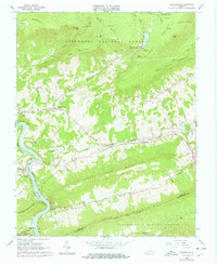
1965 Map of Eggleston
USGS Topo · Published 1978About this map
Mountain Lake sits high above the surrounding ridges, a rare natural feature in this section of the Jefferson National Forest. The landscape is dominated by the deeply carved valley of the New River, where the Norfolk and Western railway snakes along the water's edge through Eggleston and Pembroke. Evidence of the region's academic and social infrastructure is found at the University of Virginia Biological Station and several remote rural churches, including Hoges Chapel and Spruce Run Ch. Along Sinking Creek, the geography reveals unique drainage patterns where the water enters creek sinks near Maybrook. The terrain is strictly bounded by prominent heights like Butt Mountain and Gap Mountain, which define the narrow valleys that have historically funneled transportation and settlement in Giles County.
Find a feature on this map
48 named features on this map. Tap any name to fly to it.
Don’t see what you’re looking for? This feature index may not catch every label — zoom into the map to look around manually.
Map Details
Editions of this 1965 Eggleston Map
Other maps of this area

1890 · Dublin
USGS Topo · 1:125,000

1890 · Christiansburg
USGS Topo · 1:125,000

1891 · Dublin
USGS Topo · 1:125,000

1923 · Pearisburg
USGS Topo · 1:62,500

1923 · Waiteville
USGS Topo · 1:62,500

1931 · Waiteville
USGS Topo · 1:48,000

1932 · Pearisburg
USGS Topo · 1:48,000

1932 · Blacksburg
USGS Topo · 1:48,000

1937 · Pearisburg
USGS Topo · 1:62,500

1937 · Blacksburg
USGS Topo · 1:62,500