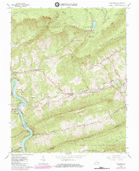
1965 Map of Eggleston
USGS Topo · Published 1985About this map
The New River carves a dramatic path through this 1960s survey of the Virginia highlands, passing the riverside settlement of Eggleston and the historic crossing at Goodwins Ferry. The landscape is dominated by the ridges of Spruce Run Mountain and Gap Mountain, while the northern reaches include the high-elevation waters of Mountain Lake and the Mountain Lake Biological Station. The valley floors reveal a network of rural life, anchored by small communities like Maybrook and several houses of worship, including Lucas Memorial Ch and Hoges Chapel. Transport and industry are evident through the Norfolk and Western railroad corridor and local operations such as a Quarry and Mine. This map captures the region after the mid-century peak of its mountain resorts but before significant modern development, preserving the locations of family cemeteries and remote mountain gaps.
Find a feature on this map
47 named features on this map. Tap any name to fly to it.
Don’t see what you’re looking for? This feature index may not catch every label — zoom into the map to look around manually.
Map Details
Editions of this 1965 Eggleston Map
Other maps of this area

1890 · Dublin
USGS Topo · 1:125,000

1890 · Christiansburg
USGS Topo · 1:125,000

1891 · Dublin
USGS Topo · 1:125,000

1923 · Pearisburg
USGS Topo · 1:62,500

1923 · Waiteville
USGS Topo · 1:62,500

1931 · Waiteville
USGS Topo · 1:48,000

1932 · Pearisburg
USGS Topo · 1:48,000

1932 · Blacksburg
USGS Topo · 1:48,000

1937 · Pearisburg
USGS Topo · 1:62,500

1937 · Blacksburg
USGS Topo · 1:62,500