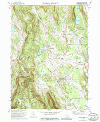
1973 Map of Egremont
USGS Topo · Published 1987About this map
Egremont and the foothills of the Berkshires dominate this 1970s landscape, where the agricultural tradition of the valley meets the growing recreational and educational infrastructure of the era. The presence of Simon's Rock Early College and Cornwall Academy points to the region's mid-century shift toward a campus-oriented economy, while the Catamount Ski Area and numerous golf courses highlight its development as a seasonal destination. Historic markers, such as the Battlesite Mon near Sheffield, sit alongside natural landmarks like Prospect Lake and the steep slopes of Mount Washington State Forest. The map also captures the distinct village clusters of North Egremont, South Egremont, and Alford, all connected by a network of local thoroughfares like Baldwin Hill Road and Townhouse Road. This detailed record documents a moment when working farms and institutional campuses coexisted before the further modernization of the New England countryside.
Find a feature on this map
72 named features on this map. Tap any name to fly to it.
Don’t see what you’re looking for? This feature index may not catch every label — zoom into the map to look around manually.
Map Details
Editions of this 1973 Egremont Map
4 editions found
Other maps of this area

1885 · Sheffield
USGS Topo · 1:62,500

1888 · Sheffield
USGS Topo · 1:62,500

1888 · Pittsfield
USGS Topo · 1:62,500

1890 · Pittsfield
USGS Topo · 1:62,500

1891 · Sheffield
USGS Topo · 1:62,500

1893 · Sheffield
USGS Topo · 1:62,500

1893 · Pittsfield
USGS Topo · 1:62,500

1894 · Pittsfield
USGS Topo · 1:62,500

1897 · Pittsfield
USGS Topo · 1:62,500

1897 · Sheffield
USGS Topo · 1:62,500