
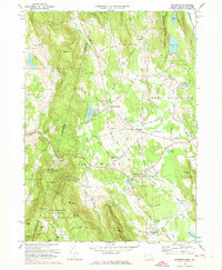
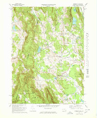
1973 Map of Egremont
USGS Topo · Published 1987About this map
The Columbia County and Berkshire County line bisects this 1970s landscape, marking the transition between the New York and Massachusetts borderlands. The central valley is anchored by the trio of settlements at North Egremont, Egremont Plain, and South Egremont, where the Green River meanders through agricultural lands. To the south and west, the terrain rises sharply into the Mount Washington State Forest, featuring prominent peaks like Mt Sterling and Mt Whitbeck. This survey captures a moment of local institutional change, noting the presence of Cornwall Academy and Simon's Rock Early College alongside recreational developments such as the Catamount Ski Area and the Great Barrington Airport. Traceable road networks include the historic Shun Toll Road and the winding Appalachian Trail, which traverses the high ground near the Bash Bish Falls State Park boundary.
Find a feature on this map
60 named features on this map. Tap any name to fly to it.
Don’t see what you’re looking for? This feature index may not catch every label — zoom into the map to look around manually.
Map Details
Editions of this 1973 Egremont Map
4 editions found

Other maps of this area

1885 · Sheffield
USGS Topo · 1:62,500

1888 · Sheffield
USGS Topo · 1:62,500

1888 · Pittsfield
USGS Topo · 1:62,500

1890 · Pittsfield
USGS Topo · 1:62,500

1891 · Sheffield
USGS Topo · 1:62,500

1893 · Sheffield
USGS Topo · 1:62,500

1893 · Pittsfield
USGS Topo · 1:62,500

1894 · Pittsfield
USGS Topo · 1:62,500

1897 · Pittsfield
USGS Topo · 1:62,500

1897 · Sheffield
USGS Topo · 1:62,500