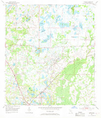
1954 Map of Ehren
USGS Topo · Published 1969About this map
Ehren stands at a pivotal rail junction in central Pasco County during the mid-1950s, where the Seaboard Air Line and the Atlantic Coast Line railroads intersect. The settlement’s local life is anchored by the Oak Grove Ch and the Ehren Cem, serving a community defined by its proximity to a complex network of water bodies. This landscape is a mosaic of cypress domes and sinkhole lakes, dominated in the southeast by the Big Cypress Swamp and the winding course of Cypress Creek. Numerous named ponds and lakes, such as Big Fish Lake, Bird Island Lakes, and Parker Lake, suggest a rural environment where land use was inextricably tied to the wet, low-lying geography. The map captures Pasco County's interior before the significant suburban expansion of the late 20th century, showing a pattern of isolated homesteads and small-scale infrastructure set against a dense aquatic wilderness.
Find a feature on this map
23 named features on this map. Tap any name to fly to it.
Don’t see what you’re looking for? This feature index may not catch every label — zoom into the map to look around manually.
Map Details
Editions of this 1954 Ehren Map
4 editions found
Other maps of this area

1943 · Odessa
USGS Topo · 1:24,000

1943 · Lutz
USGS Topo · 1:24,000

1944 · Wesley Chapel
USGS Topo · 1:31,680

1944 · Lutz
USGS Topo · 1:31,680

1944 · Odessa
USGS Topo · 1:31,680

1949 · Odessa
USGS Topo · 1:25,000

1954 · Spring Lake
USGS Topo · 1:24,000

1954 · Ehren
USGS Topo · 1:24,000

1954 · San Antonio
USGS Topo · 1:24,000

1954 · Fivay
USGS Topo · 1:24,000