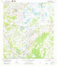
1954 Map of Ehren
USGS Topo · Published 1979About this map
Ehren and the surrounding pine and cypress terrain of Pasco County are captured here in a mid-century period of transition. The settlement, established along the Atlantic Coast Line railroad, is marked by the presence of the Ehren Cem and the nearby Oak Grove Ch. This landscape is defined by an extensive network of freshwater bodies, ranging from the large Big Fish Lake and Parker Lake to smaller isolated basins like Way Pond and Mann Pond. To the east, the vast Big Cypress Swamp dominates the topography, through which Cypress Creek meanders toward the southern boundary. Parallel rail lines, including the Seaboard Air Line to the west, illustrate the importance of timber and agricultural transport in this region before the significant suburban expansion of later decades.
Find a feature on this map
25 named features on this map. Tap any name to fly to it.
Don’t see what you’re looking for? This feature index may not catch every label — zoom into the map to look around manually.
Map Details
Editions of this 1954 Ehren Map
4 editions found
Other maps of this area

1943 · Odessa
USGS Topo · 1:24,000

1943 · Lutz
USGS Topo · 1:24,000

1944 · Wesley Chapel
USGS Topo · 1:31,680

1944 · Lutz
USGS Topo · 1:31,680

1944 · Odessa
USGS Topo · 1:31,680

1949 · Odessa
USGS Topo · 1:25,000

1954 · Spring Lake
USGS Topo · 1:24,000

1954 · Ehren
USGS Topo · 1:24,000

1954 · San Antonio
USGS Topo · 1:24,000

1954 · Fivay
USGS Topo · 1:24,000