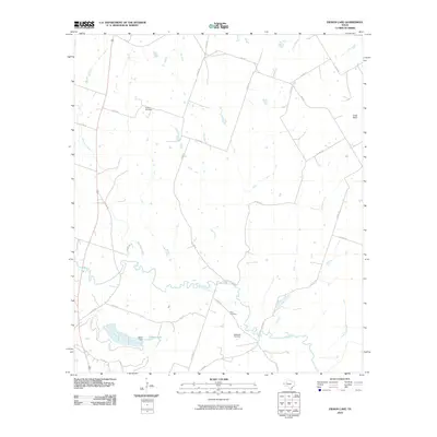
2010 Map of Eidson Lake
USGS Topo · Published 2010About this map
The Leon River meanders through this portion of Hamilton County, shaping a landscape defined by its riparian corridors and upland cattle country. This 2010 survey records the rural character of the region, where a network of county roads like Co RD 211 and Co RD 213 provides access to family cemeteries and agricultural lands. For local historians and genealogists, the map identifies three significant burial sites: Peacher Cemetery in the north, and both Gann Cemetery and Massingill Cemetery situated south of the river. The water management of the area is anchored by Harris Dam, which forms Eidson Lake on the western edge of the quadrangle. Several seasonal and perennial watercourses, including Mesquite Creek, Gum Branch, and Indian Creek, drain the surrounding terrain toward the river basin, while Long Point stands as a prominent elevation feature in the northeast.
Find a feature on this map
34 named features on this map. Tap any name to fly to it.
Don’t see what you’re looking for? This feature index may not catch every label — zoom into the map to look around manually.
Map Details
Editions of this 2010 Eidson Lake Map
This is the sole edition of this map. No revisions or reprints were ever made.
Other maps of this area

1888 · Hamilton
USGS Topo · 1:125,000

1888 · Meridian
USGS Topo · 1:125,000

1894 · Hamilton
USGS Topo · 1:125,000

1894 · Meridian
USGS Topo · 1:125,000

1954 · Brownwood
USGS Topo · 1:250,000

1954 · Waco
USGS Topo · 1:250,000

1955 · Waco
USGS Topo · 1:250,000

1956 · Gentrys Mill
USGS Topo · 1:24,000

1956 · Hico
USGS Topo · 1:62,500

1956 · Hamilton
USGS Topo · 1:62,500