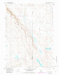
1966 Map of Eightmile Lake
USGS Topo · Published 1981About this map
The Continental Divide winds through this high-altitude landscape, separating the basins of the American West. The terrain is defined by dramatic geological features like the Big Wamsutter Rim and the Big Hill, which overlook a series of ephemeral and semi-permanent water bodies including Dry Lake, Eightmile Lake, and the naturally occurring Echo Depression. These features underscore the hydrology of a region where water is a scarce and vital resource, evidenced further by the presence of the Government Reservoir.
Find a feature on this map
19 named features on this map. Tap any name to fly to it.
Don’t see what you’re looking for? This feature index may not catch every label — zoom into the map to look around manually.
Map Details
Editions of this 1966 Eightmile Lake Map
2 editions found
Other maps of this area

1954 · Rawlins
USGS Topo · 1:250,000

1954 · Rock Springs
USGS Topo · 1:250,000

1958 · Rawlins
USGS Topo · 1:250,000

1958 · Rock Springs
USGS Topo · 1:250,000

1962 · Rawlins
USGS Topo · 1:250,000

1962 · Rock Springs
USGS Topo · 1:250,000

1966 · Wamsutter
USGS Topo · 1:24,000

1966 · Creston
USGS Topo · 1:24,000

1966 · High Point
USGS Topo · 1:24,000

1966 · Eightmile Lake
USGS Topo · 1:24,000