1957 Map of El Centro
USGS Topo · Published 1958About this map
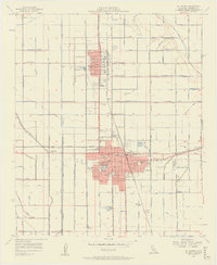
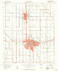
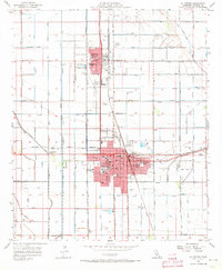
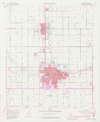
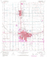
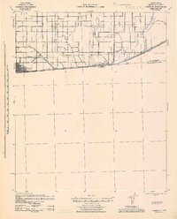
The city of El Centro serves as the focal point of this mid-century survey, revealing a landscape defined by an extensive network of irrigation infrastructure. This desert agricultural hub is crisscrossed by systems like the Central Canal, Rose Canal, and numerous laterals including Date Lateral 10 and Eucalyptus Lateral 17. The urban core is well-developed, housing the Court House, City Hall, and the Imperial Valley College. To the north, the smaller settlement of Imperial is distinguished by its own civic footprint, featuring the Imperial County Airport and the nearby Fairgrounds. The presence of the Southern Pacific railroad and specialized facilities like the Cotton Gin and several Labor Camps highlights the region's historical reliance on industrial-scale farming and transport during this era of California's development.
Find a feature on this map
94 named features on this map. Tap any name to fly to it.
Don’t see what you’re looking for? This feature index may not catch every label — zoom into the map to look around manually.
Map Details
Editions of this 1957 El Centro Map
5 editions found
Other maps of this area

1907 · Holtville
USGS Topo · 1:125,000

1915 · El Centro
USGS Topo · 1:125,000

1940 · Brawley
USGS Topo · 1:62,500
1940 · Heber
USGS Topo · 1:62,500

1940 · Alamorio
USGS Topo · 1:62,500
1940 · Calexico
USGS Topo · 1:62,500

1942 · El Centro
USGS Topo · 1:250,000
1943 · Heber
USGS Topo · 1:62,500

1943 · Brawley
USGS Topo · 1:62,500
1943 · Calexico
USGS Topo · 1:62,500