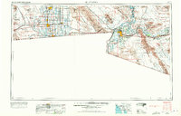
1958 Map of El Centro
USGS Topo · Published 1972About this map
Irrigated agriculture and desert industry define this mid-century portrait of the Imperial Valley. Extensive water infrastructure, including the All American Canal and Coachella Canal, transforms the arid landscape between El Centro and the Colorado River. To the east, the map details the rugged mining and military geography of the Chocolate Mountains and the Yuma Proving Ground. Significant rail corridors like the Southern Pacific Railroad and the San Diego and Arizona Eastern Railway connect border towns like Calexico and San Luis to broader regional markets. The map also documents the expansive military footprints of the era, from U.S. Naval Air Facility El Centro to the massive Luke Air Force Bombing and Gunnery Range stretching across the Lechuguilla Desert. Historic mining operations, such as the Cargo Muchacho Mine and American Girl Mine, are noted near the desert ranges, anchoring the area's extraction history.
Find a feature on this map
74 named features on this map. Tap any name to fly to it.
Don’t see what you’re looking for? This feature index may not catch every label — zoom into the map to look around manually.
Map Details
Editions of this 1958 El Centro Map
4 editions found

Other maps of this area

1903 · Yuma
USGS Topo · 1:125,000

1905 · Yuma
USGS Topo · 1:125,000

1907 · Holtville
USGS Topo · 1:125,000

1915 · El Centro
USGS Topo · 1:125,000

1926 · Fortuna
USGS Topo · 1:62,500

1926 · Wellton
USGS Topo · 1:62,500

1926 · Mohawk
USGS Topo · 1:62,500

1928 · Mohawk
USGS Topo · 1:62,500

1928 · Norton
USGS Topo · 1:62,500

1929 · Fortuna
USGS Topo · 1:62,500