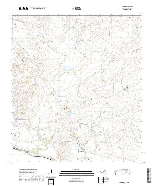
2022 Map of El Indio
USGS Topo · Published 2022About this map
The border community of El Indio is situated along the high banks above the Rio Grande, where the international boundary separates Texas from the Estados Unidos Mexicanos. This 2022 survey shows a settlement pattern defined by its proximity to the river and the arterial connections of El Indio Hwy and FM 1021. The surrounding landscape is dominated by ephemeral drainages including Saus Cr, Cuevas Cr, and Mule Cr, which carve through the arid Maverick County terrain. Local street names like Antonio Rivas Rd and San Ambrosio St provide a detailed look at the modern layout of this small river town. To the northeast, the presence of Halsell Lake Number 2 highlights the regional reliance on managed water resources in this dry brushland environment.
Find a feature on this map
19 named features on this map. Tap any name to fly to it.
Don’t see what you’re looking for? This feature index may not catch every label — zoom into the map to look around manually.
Map Details
Editions of this 2022 El Indio Map
This is the sole edition of this map. No revisions or reprints were ever made.
Other maps of this area

1940 · Cometa
USGS Topo · 1:62,500

1940 · Eagle Pass
USGS Topo · 1:62,500

1941 · Botella Creek
USGS Topo · 1:62,500

1957 · Indio Creek
USGS Topo · 1:62,500

1957 · Botella Creek
USGS Topo · 1:62,500

1958 · Eagle Pass
USGS Topo · 1:250,000

1965 · Eagle Pass
USGS Topo · 1:250,000
1974 · Sacatosa Tank
USGS Topo · 1:24,000
1982 · Indio Tank
USGS Topo · 1:24,000
1982 · Eagle Pass NE
USGS Topo · 1:24,000