
1933 Map of El Mirage
USGS Topo · Published 1933About this map
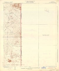
Antelope Valley transitions here from the open desert floor into the complex topography of the lower foothills, where the early 1930s landscape is defined by its isolation and the necessity of water. The solitary Walton Place stands as a focal point for local history research, representing the sparse homesteading and ranching efforts that characterized this portion of Los Angeles and San Bernardino counties during the era. The presence of a strategically located Well and the long straight-edge paths of El Mirage Road and Avenue P reflect a grid of human transit imposed upon the natural terrain of El Mirage. This preliminary survey also documents an extensive unsurveyed area to the east, highlighting the frontier-like state of mapping in this region just before more intensive mid-century developments.
Find a feature on this map
8 named features on this map. Tap any name to fly to it.
Don’t see what you’re looking for? This feature index may not catch every label — zoom into the map to look around manually.
Map Details
Editions of this 1933 El Mirage Map
2 editions found
Other maps of this area

1930 · Black Butte
USGS Topo · 1:24,000

1930 · El Mirage
USGS Topo · 1:24,000

1930 · Angle
USGS Topo · 1:24,000

1930 · Wilsona
USGS Topo · 1:24,000

1931 · Adobe
USGS Topo · 1:24,000

1931 · Hi Vista
USGS Topo · 1:24,000

1932 · Angle
USGS Topo · 1:24,000

1933 · Black Butte
USGS Topo · 1:24,000

1934 · Adobe
USGS Topo · 1:24,000

1935 · Hi Vista
USGS Topo · 1:24,000