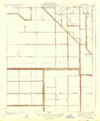
1936 Map of El Rico Ranch
USGS Topo · Published 1936About this map
The expansive and dry Tulare Lake Bed dominates this landscape in the mid-1930s, revealing a terrain entirely transformed by water management and large-scale agricultural operations. The grid-like patterns of Pueblo Avenue, Redding Avenue, and 10th Avenue segment the former lake floor, serviced by a complex system of hydraulic infrastructure. Engineering projects like the Lovelace Levee, South Levee, and the Reclamation Ditch 16-18 demonstrate the intense effort required to reclaim this land for cultivation.
Find a feature on this map
24 named features on this map. Tap any name to fly to it.
Don’t see what you’re looking for? This feature index may not catch every label — zoom into the map to look around manually.
Map Details
Editions of this 1936 El Rico Ranch Map
3 editions found
Other maps of this area

1914 · Lost Hills
USGS Topo · 1:125,000

1928 · Waukena
USGS Topo · 1:31,680

1928 · Corcoran
USGS Topo · 1:31,680

1929 · Guernsey
USGS Topo · 1:31,680

1929 · Stratford
USGS Topo · 1:31,680

1929 · West Alpaugh
USGS Topo · 1:31,680

1931 · Harvester
USGS Topo · 1:31,680

1932 · El Rico Ranch
USGS Topo · 1:31,680

1932 · Dudley Ridge
USGS Topo · 1:31,680

1933 · Chatom Ranch
USGS Topo · 1:31,680