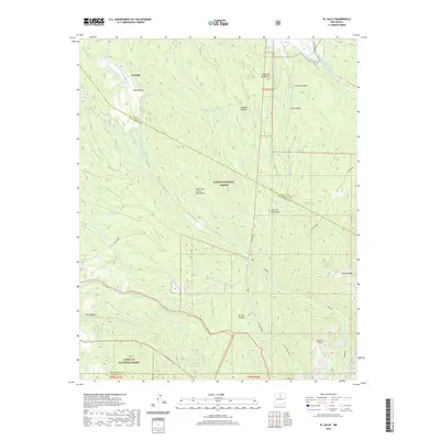
2020 Map of El Valle
USGS Topo · Published 2020About this map
El Valle and the surrounding high-altitude terrain of the Sangre de Cristo Mountains define this northern New Mexico landscape. The community's agricultural heritage is visible through an intricate network of irrigation ditches, including the Acequia de Abajo de el Valle and the Acequia del Llano de San Miguel, which divert water from the Rio de las Trampas to support local fields. This 2020 survey documents the convergence of the Carson National Forest and the Santa Fe National Forest, marking a transition from the valley floor to the alpine heights of Jicarilla Peak. Water management remains a primary feature of the region, from the high San Leonardo Lakes and Hidden Lake to modern infrastructure like the Osha Ridge Trick Tank. The map also traces the boundary between Rio Arriba, Taos, and Santa Fe counties amidst a complex system of canyons such as Osha Canyon and Cebadilla Canyon.
Find a feature on this map
43 named features on this map. Tap any name to fly to it.
Don’t see what you’re looking for? This feature index may not catch every label — zoom into the map to look around manually.
Map Details
Editions of this 2020 El Valle Map
This is the sole edition of this map. No revisions or reprints were ever made.
Other maps of this area

1889 · Santa Fe
USGS Topo · 1:125,000

1894 · Santa Fe
USGS Topo · 1:125,000

1953 · Truchas
USGS Topo · 1:24,000

1953 · Sierra Mosca
USGS Topo · 1:24,000

1953 · Trampas
USGS Topo · 1:24,000

1954 · Santa Fe
USGS Topo · 1:250,000

1954 · Raton
USGS Topo · 1:250,000

1958 · Raton
USGS Topo · 1:250,000

1958 · Santa Fe
USGS Topo · 1:250,000
1963 · Truchas Peak
USGS Topo · 1:24,000