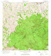
1958 Map of El Yunque
USGS Topo · Published 1960About this map
The high peaks of the Sierra de Luquillo dominate this 1950s terrain study, where the lush rainforest meets the coastal lowlands of Rio Grande. The landscape is defined by the massive presence of El Yunque, Mte Britton, and El Toro (Southwest Peak), forming a hydrological hub where headwaters like the Rio Espiritu Santo and Rio Mameyes begin their descent. Cultural features are concentrated along the northern roads, including the Mameyes (Palmer PO) settlement and the specialized Escuela Segunda Unidad Casiano Cepeda. Historically significant markers of the era include the Area de Recreo La Mina and the nearby Mina, reflecting the dual use of the mountain as both a recreation destination and a site of former industrial interest. This map captures a moment when the Estacion Guardabosque and various youth camps like Campamento Eliza Colberg were integral to the area's forest management and social fabric.
Find a feature on this map
71 named features on this map. Tap any name to fly to it.
Don’t see what you’re looking for? This feature index may not catch every label — zoom into the map to look around manually.
Map Details
Editions of this 1958 El Yunque Map
This is the sole edition of this map. No revisions or reprints were ever made.
Other maps of this area

1940 · Carolina
USGS Topo · 1:30,000

1941 · Rio Grande
USGS Topo · 1:30,000

1941 · Carolina
USGS Topo · 1:30,000

1945 · El Yunque
USGS Topo · 1:30,000

1946 · El Yunque
USGS Topo · 1:30,000

1946 · Humacao
USGS Topo · 1:30,000

1946 · Gurabo
USGS Topo · 1:30,000

1946 · Juncos
USGS Topo · 1:30,000

1946 · Naguabo
USGS Topo · 1:30,000

1946 · Fajardo
USGS Topo · 1:30,000
Featured Places
- Hacienda Jordán, Río Grande
- Colinas Tres T, Río Grande
- Palma Sola, Canóvanas
- Comunidad La Vega, Río Grande
- Sector Rosado, Las Piedras