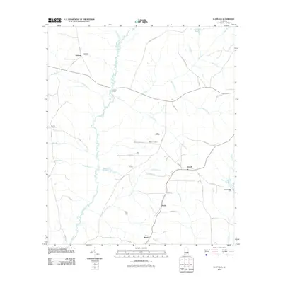
2011 Map of Elamville
USGS Topo · Published 2011About this map
The Pea River carves a winding path through the heart of this Barbour County landscape, serving as a primary geographical anchor for the surrounding rural communities. Settled areas like Elamville, Richland, and Bethel are connected by a network of county roads that navigate the many tributaries feeding the river, including Buckhorn Creek, Richland Creek, and Danner Creek. The map is particularly rich in genealogical data, preserving the locations of numerous family and community burial grounds such as Richland Cemetery, Adam Cemetery, and Dansby Cemetery. Evidence of local industry and water management appears at the Easterling Mill Pond Dam and Sutton Lake Dam, while landmarks like Joiners Bridge and Barefoot Spring offer specific points of interest for local historians. This survey captures a rural Alabama landscape where the legacy of early settlements and family landholdings remains clearly etched into the modern topography.
Find a feature on this map
55 named features on this map. Tap any name to fly to it.
Don’t see what you’re looking for? This feature index may not catch every label — zoom into the map to look around manually.
Map Details
Editions of this 2011 Elamville Map
This is the sole edition of this map. No revisions or reprints were ever made.
Other maps of this area

1948 · Brundidge
USGS Topo · 1:62,500

1950 · Brundidge
USGS Topo · 1:62,500

1953 · Dothan
USGS Topo · 1:250,000

1954 · Dothan
USGS Topo · 1:250,000

1955 · Dothan
USGS Topo · 1:250,000

1960 · Brundidge
USGS Topo · 1:24,000

1960 · Brundidge SE
USGS Topo · 1:24,000

1962 · Brundidge
USGS Topo · 1:25,000
1962 · Brundidge SE
USGS Topo · 1:25,000

1968 · Louisville
USGS Topo · 1:24,000