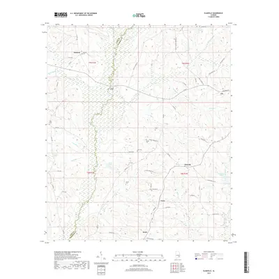
2018 Map of Elamville
USGS Topo · Published 2018About this map
The Pea River carves a winding path along the western boundary of Barbour and Pike counties, defining the agricultural character of this landscape in late 2015. Several small rural communities, including Elamville, Doster, and Bethel, anchor the local road network, which is dominated by routes like Co RD 83 and River RD. For those tracing local family histories, the area is punctuated by numerous family and community burial grounds such as Richland Cem, Dansby Cem, and Carr Cem. The map illustrates a landscape of intermittent streams like Beaver Cr and Thompson Cr, alongside specific landmarks like Joiners Bridge and Barefoot Spring. The presence of Burke Ponds and Easterlings Pond near the various drainage branches highlights the hydrological importance of the region's lowlands and wetlands for the surrounding farms and woodlands.
Find a feature on this map
72 named features on this map. Tap any name to fly to it.
Don’t see what you’re looking for? This feature index may not catch every label — zoom into the map to look around manually.
Map Details
Editions of this 2018 Elamville Map
This is the sole edition of this map. No revisions or reprints were ever made.
Other maps of this area

1948 · Brundidge
USGS Topo · 1:62,500

1950 · Brundidge
USGS Topo · 1:62,500

1953 · Dothan
USGS Topo · 1:250,000

1954 · Dothan
USGS Topo · 1:250,000

1955 · Dothan
USGS Topo · 1:250,000

1960 · Brundidge
USGS Topo · 1:24,000

1960 · Brundidge SE
USGS Topo · 1:24,000

1962 · Brundidge
USGS Topo · 1:25,000
1962 · Brundidge SE
USGS Topo · 1:25,000

1968 · Louisville
USGS Topo · 1:24,000