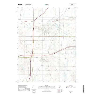
2019 Map of Elberfeld
USGS Topo · Published 2019About this map
The town of Elberfeld serves as the focal point of this southwestern Indiana landscape, where the borders of Gibson, Warrick, and Vanderburgh counties converge. This modern survey illustrates a region defined by its complex drainage network and historic transportation corridors. The path of the historic Wabash and Erie Canal is still discernible as it cuts through the terrain near Buckskin, paralleling contemporary routes like the Bluegrass Cr. Local history is deeply embedded in the land, marked by numerous burial sites such as Northview Cem, Zion Cem, and Williams Cem. The topography is generally low-lying, characterized by extensive wetlands and water bodies including Pigeon Creek, Warrens Lake, and Bell Conservation Lake. A prominent local landmark, Lost Hill, rises above the surrounding flats east of the intersection of W State Rd 68 and the Interstate highway, providing a distinct geographic marker in this agricultural and industrial setting.
Find a feature on this map
61 named features on this map. Tap any name to fly to it.
Don’t see what you’re looking for? This feature index may not catch every label — zoom into the map to look around manually.
Map Details
Editions of this 2019 Elberfeld Map
This is the sole edition of this map. No revisions or reprints were ever made.
Other maps of this area

1901 · Princeton
USGS Topo · 1:62,500

1901 · Haubstadt
USGS Topo · 1:62,500

1902 · Ditney
USGS Topo · 1:125,000

1902 · Boonville
USGS Topo · 1:62,500

1903 · Haubstadt
USGS Topo · 1:62,500

1903 · Petersburg
USGS Topo · 1:62,500

1903 · Princeton
USGS Topo · 1:62,500

1903 · Patoka
USGS Topo · 1:125,000

1956 · Vincennes
USGS Topo · 1:250,000

1957 · Vincennes
USGS Topo · 1:250,000