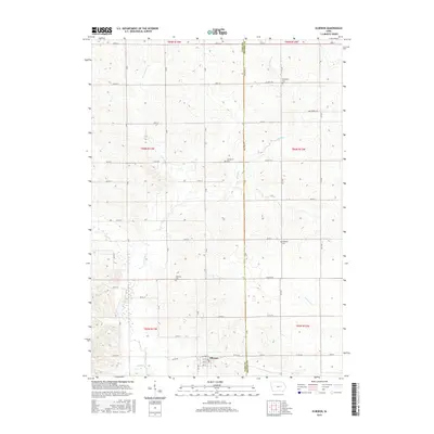
2015 Map of Elberon
USGS Topo · Published 2015About this map
Elberon serves as the primary settlement on this landscape, its grid of streets including Railway St, 1st St, and 2nd St situated just north of Wolf Cr. The surrounding terrain is a mosaic of agricultural sections defined by a rigid section-line road network. Scattered throughout the rural landscape are smaller nodes of community history, such as the settlement of Walthom and several family-named burial grounds. Genealogists can identify the locations of Houghton Cem, Lamprecht Cem, and Twogood Cem, which are preserved within the farm fields. The drainage patterns are dominated by the winding paths of Salt Creek and its tributaries, including E Br Salt Cr and Stein Cr, which break the geometric regularity of the county roads and townships.
Find a feature on this map
47 named features on this map. Tap any name to fly to it.
Don’t see what you’re looking for? This feature index may not catch every label — zoom into the map to look around manually.
Map Details
Editions of this 2015 Elberon Map
This is the sole edition of this map. No revisions or reprints were ever made.
Other maps of this area

1954 · Waterloo
USGS Topo · 1:250,000

1954 · Des Moines
USGS Topo · 1:250,000

1955 · Waterloo
USGS Topo · 1:250,000

1956 · Des Moines
USGS Topo · 1:250,000

1957 · Des Moines
USGS Topo · 1:250,000

1965 · Keystone South
USGS Topo · 1:24,000

1968 · Belle Plaine
USGS Topo · 1:24,000

1968 · Chelsea
USGS Topo · 1:24,000

1969 · Des Moines
USGS Topo · 1:250,000
1971 · Elberon
USGS Topo · 1:24,000