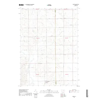
2018 Map of Elberon
USGS Topo · Published 2018About this map
Elberon sits at the base of this landscape, its street grid defined by the path of Railway St as it skirts the northern edge of the Wolf Cr basin. The surrounding terrain of the Tama and Benton county line is marked by a network of drainage systems, including Stein Cr and E Br Salt Cr, which carve a rolling topography into the agricultural heartland. Genealogists and local researchers will find several family-named burial sites scattered across the townships, such as Houghton Cem in the northeast and Walthom Cem near the center of the sheet. The map documents the enduring rural infrastructure of the region, where a dense grid of numbered roads like 230th St and Co Hwy E40 connects isolated farmsteads and historic cemeteries to the local trade center.
Find a feature on this map
44 named features on this map. Tap any name to fly to it.
Don’t see what you’re looking for? This feature index may not catch every label — zoom into the map to look around manually.
Map Details
Editions of this 2018 Elberon Map
This is the sole edition of this map. No revisions or reprints were ever made.
Other maps of this area

1954 · Waterloo
USGS Topo · 1:250,000

1954 · Des Moines
USGS Topo · 1:250,000

1955 · Waterloo
USGS Topo · 1:250,000

1956 · Des Moines
USGS Topo · 1:250,000

1957 · Des Moines
USGS Topo · 1:250,000

1965 · Keystone South
USGS Topo · 1:24,000

1968 · Belle Plaine
USGS Topo · 1:24,000

1968 · Chelsea
USGS Topo · 1:24,000

1969 · Des Moines
USGS Topo · 1:250,000
1971 · Elberon
USGS Topo · 1:24,000