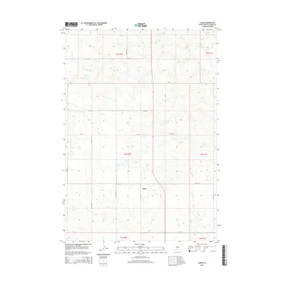
2015 Map of Elbon
USGS Topo · Published 2015About this map
Elbon sits as a quiet focal point in this Haakon County landscape, positioned where the grid of sectional roads meets the winding drainage of W Plum Cr. The terrain is defined by the subtle shift from the upland plains down into the creek valleys, with Kroetch Lake serving as a prominent water feature in the western half of the quadrangle. The township structure is clearly delineated, showing the intersection of t4n r20e and surrounding territories through a network of precisely laid out gravel and dirt routes such as Hilland Rd and Brooks St. This survey captures the rural character of the South Dakota prairie, where the placement of small reservoirs and the paths of intermittent streams like Buzzard Cr dictate the layout of the local agricultural infrastructure and property boundaries in the early 21st century.
Find a feature on this map
22 named features on this map. Tap any name to fly to it.
Don’t see what you’re looking for? This feature index may not catch every label — zoom into the map to look around manually.
Map Details
Editions of this 2015 Elbon Map
This is the sole edition of this map. No revisions or reprints were ever made.
Other maps of this area
1954 · Pierre
USGS Topo · 1:250,000
1958 · Pierre
USGS Topo · 1:250,000
1983 · Philip
USGS Topo · 1:100,000
1983 · Hilland
USGS Topo · 1:24,000
1983 · Elevenmile Corner
USGS Topo · 1:24,000
1983 · Hartley
USGS Topo · 1:24,000
1983 · Milesville
USGS Topo · 1:24,000
1983 · Tornado Ranch
USGS Topo · 1:24,000
1983 · Lucerne
USGS Topo · 1:24,000
1983 · Grindstone Butte
USGS Topo · 1:24,000