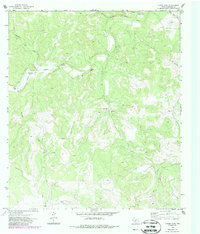
1971 Map of Elbow Lake
USGS Topo · Published 1987About this map
The South Llano River carves a winding path through the Edwards County highlands, defining a landscape of deep drainages and isolated plateaus. In the early 1970s, this area remained largely defined by large-scale ranching operations, centered on sites like the Taylor Ranch. The hydrology of the region is notably complex, with a series of small, distinct water bodies including McKenzie Lake, Black Lake, Mud Lake, and the eponymous Elbow Lake clustered near the river's northern bend.
Find a feature on this map
15 named features on this map. Tap any name to fly to it.
Don’t see what you’re looking for? This feature index may not catch every label — zoom into the map to look around manually.
Map Details
Editions of this 1971 Elbow Lake Map
2 editions found
Other maps of this area

1893 · Rock Springs
USGS Topo · 1:125,000

1954 · Sonora
USGS Topo · 1:250,000

1958 · Sonora
USGS Topo · 1:250,000

1962 · Hill Ranch
USGS Topo · 1:24,000

1962 · Stewart Ranch
USGS Topo · 1:24,000
1962 · Bundy Ranch
USGS Topo · 1:24,000
1971 · Paint Rock Spring
USGS Topo · 1:24,000
1971 · Ray Lake SE
USGS Topo · 1:24,000
1971 · Devils Sinkhole
USGS Topo · 1:24,000
1971 · Rocksprings
USGS Topo · 1:24,000