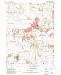
1993 Map of Elburn
USGS Topo · Published 1994About this map
The village of Elburn and the surrounding townships of Campton and Blackberry define this region of Kane County during the early 1990s. The landscape is characterized by a mix of agricultural heritage and increasing suburban development, with many small family burying grounds such as Blackberry Cem and New Hampshire Cem preserved amidst the shifting land use. The Chicago and North Western railway corridor provides a clear industrial and transport axis through the southern portion of the sheet, passing through La Fox.
Find a feature on this map
56 named features on this map. Tap any name to fly to it.
Don’t see what you’re looking for? This feature index may not catch every label — zoom into the map to look around manually.
Map Details
Editions of this 1993 Elburn Map
This is the sole edition of this map. No revisions or reprints were ever made.
Other maps of this area

1925 · Elgin
USGS Topo · 1:62,500

1932 · Geneva
USGS Topo · 1:62,500

1937 · Sycamore
USGS Topo · 1:62,500

1938 · Genoa
USGS Topo · 1:62,500

1940 · Elgin
USGS Topo · 1:62,500

1948 · Geneva
USGS Topo · 1:62,500

1949 · Geneva
USGS Topo · 1:24,000

1950 · Aurora North
USGS Topo · 1:24,000

1954 · Rockford
USGS Topo · 1:250,000

1955 · Rockford
USGS Topo · 1:250,000