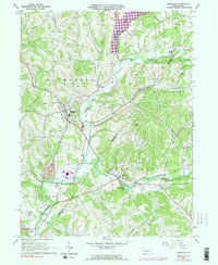
1964 Map of Elderton
USGS Topo · Published 1991About this map
The boundary between Armstrong Co and Indiana Co runs through this section of Western Pennsylvania, where the landscape is defined by the winding course of Crooked Creek and its many tributaries. The 1960s economy is clearly visible through numerous Gas Wells and a prominent Conveyor system near Idaho, reflecting the region's industrial ties to energy production. Local life centers on established boroughs and settlements like Elderton, Shelocta, and Atwood, each connected by a network of rural roads and the Baltimore and Ohio railroad line in the southern valley.
Find a feature on this map
43 named features on this map. Tap any name to fly to it.
Don’t see what you’re looking for? This feature index may not catch every label — zoom into the map to look around manually.
Map Details
Editions of this 1964 Elderton Map
3 editions found
Other maps of this area

1901 · Rural Valley
USGS Topo · 1:62,500

1902 · Indiana
USGS Topo · 1:62,500

1902 · Elders Ridge
USGS Topo · 1:62,500

1903 · Rural Valley
USGS Topo · 1:62,500

1904 · Elders Ridge
USGS Topo · 1:62,500

1909 · Smicksburg
USGS Topo · 1:62,500

1938 · Smicksburg
USGS Topo · 1:62,500

1939 · Smicksburg
USGS Topo · 1:62,500

1953 · Pittsburgh
USGS Topo · 1:250,000

1954 · Pittsburgh
USGS Topo · 1:250,000