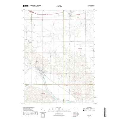
2018 Map of Eldon
USGS Topo · Published 2018About this map
The Des Moines River cuts through this corner of Southeast Iowa, anchoring the town of Eldon, while the historic community of Ashland and the city of Batavia sit further north. This area is a significant landscape for genealogists, as it preserves the locations of numerous burial grounds scattered across the townships, including the Iowaville Cem and Ellsworth Cem. The terrain is defined by the drainage basins of Rock Cr, Chippewa Cr, and Stump Cr as they flow toward the river valley.
Find a feature on this map
53 named features on this map. Tap any name to fly to it.
Don’t see what you’re looking for? This feature index may not catch every label — zoom into the map to look around manually.
Map Details
Editions of this 2018 Eldon Map
This is the sole edition of this map. No revisions or reprints were ever made.
Other maps of this area

1954 · Centerville
USGS Topo · 1:250,000
1954 · Des Moines
USGS Topo · 1:250,000
1956 · Des Moines
USGS Topo · 1:250,000
1956 · Farson
USGS Topo · 1:24,000
1956 · Agency
USGS Topo · 1:24,000
1956 · Ottumwa North
USGS Topo · 1:62,500
1956 · Ottumwa South
USGS Topo · 1:62,500
1957 · Des Moines
USGS Topo · 1:250,000
1957 · Centerville
USGS Topo · 1:250,000
1958 · Centerville
USGS Topo · 1:250,000