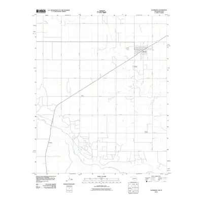
2010 Map of Eldorado
USGS Topo · Published 2010About this map
Eldorado sits at a historic crossroads in Jackson County, where a grid of rural section roads meets the diagonal path of the railway. This landscape is defined by its relationship to the Red River, which carves the southern boundary of the quadrangle and forms the border between Oklahoma and Texas. The area is a mosaic of agricultural parcels served by a systematic network of routes like e1760 RD and n1840 RD, reflecting the organized land management of the early 21st century. Genealogists will find significant value in the distribution of local burial grounds, including the Eldorado Cemetery just south of town, Antioch Cemetery to the southwest, and Durham Cemetery in the southeast. These sites, along with the settlement of Carnes near the river, trace the historical footprint of small-town life and rural commerce along the Sandy Creek drainage basin.
Find a feature on this map
21 named features on this map. Tap any name to fly to it.
Don’t see what you’re looking for? This feature index may not catch every label — zoom into the map to look around manually.
Map Details
Editions of this 2010 Eldorado Map
This is the sole edition of this map. No revisions or reprints were ever made.
Other maps of this area

1955 · Lawton
USGS Topo · 1:250,000

1960 · Goodlett
USGS Topo · 1:62,500

1960 · Quanah
USGS Topo · 1:62,500

1961 · Hollis
USGS Topo · 1:62,500

1971 · Duke SW
USGS Topo · 1:24,000

1971 · Prairie Hill
USGS Topo · 1:24,000

1975 · Hollis SE
USGS Topo · 1:24,000

1975 · Quanah NE
USGS Topo · 1:24,000

1975 · Quanah NW
USGS Topo · 1:24,000
1984 · Quanah NE
USGS Topo · 1:24,000