
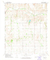
1961 Map of Hollis
USGS Topo · Published 1963About this map
The Hollis township serves as a bustling hub in Southwest Oklahoma during the early 1960s, defined by its organized grid and community landmarks like the High School, Baseball Park, and a Drive-in Theater. To the east, the smaller settlement of Gould sits along the Missouri Kansas Texas railroad line. The landscape is carved by the broad Prairie Dog Town Fork Red River, which marks the state boundary between Oklahoma and Texas.
Find a feature on this map
42 named features on this map. Tap any name to fly to it.
Don’t see what you’re looking for? This feature index may not catch every label — zoom into the map to look around manually.
Map Details
Editions of this 1961 Hollis Map
This is the sole edition of this map. No revisions or reprints were ever made.
Other maps of this area

1954 · Plainview
USGS Topo · 1:250,000

1955 · Lawton
USGS Topo · 1:250,000

1958 · Plainview
USGS Topo · 1:250,000

1960 · Goodlett
USGS Topo · 1:62,500

1960 · Loco
USGS Topo · 1:62,500

1960 · Quanah
USGS Topo · 1:62,500

1964 · Dodson
USGS Topo · 1:24,000

1967 · Kirkland North
USGS Topo · 1:24,000

1971 · Russell
USGS Topo · 1:24,000
1971 · Mc Knight
USGS Topo · 1:24,000