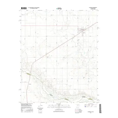
2016 Map of Eldorado
USGS Topo · Published 2016About this map
Eldorado serves as the primary hub of this landscape, situated near the Oklahoma-Texas border where the grid of county roads meets the diagonal rail line. The town's layout is defined by streets like N Lloyd St and W Glenn St, with the Eldorado Cem located just to the south. Further south, the terrain descends toward the wide valley of the Red River, which forms the natural boundary between Jackson County and Hardeman County. This 2016 survey illustrates the persistent agricultural and rural character of the region, anchored by historical landmarks like Antioch Cem and Durham Cem. The presence of the settlement at Carnes near the riverbank suggests a long-standing relationship between the local community and the water, while a dense network of roads such as E1760 Rd and N1810 Rd connects these scattered points of interest across the plains.
Find a feature on this map
36 named features on this map. Tap any name to fly to it.
Don’t see what you’re looking for? This feature index may not catch every label — zoom into the map to look around manually.
Map Details
Editions of this 2016 Eldorado Map
This is the sole edition of this map. No revisions or reprints were ever made.
Other maps of this area

1955 · Lawton
USGS Topo · 1:250,000
1960 · Goodlett
USGS Topo · 1:62,500
1960 · Quanah
USGS Topo · 1:62,500
1961 · Hollis
USGS Topo · 1:62,500
1971 · Duke SW
USGS Topo · 1:24,000
1971 · Prairie Hill
USGS Topo · 1:24,000
1975 · Hollis SE
USGS Topo · 1:24,000
1975 · Quanah NE
USGS Topo · 1:24,000
1975 · Quanah NW
USGS Topo · 1:24,000
1984 · Quanah NE
USGS Topo · 1:24,000