
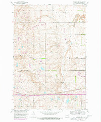
1951 Map of Eldridge NW
USGS Topo · Published 1954About this map
Northern Pacific railroad tracks bisect this Stutsman County landscape, following the low-lying terrain of the Minneapolis Flats through the townships of Windsor and Eldridge. Compiled as part of the Missouri River Basin development program, this 1951 survey documents a transition from the glacial pothole lakes of the north to the managed agricultural divisions in the south. Notable water bodies include the large Deer Lake and the smaller Adkinson Lake, which sit amidst a topography marked by subtle depressions and rises. Local infrastructure is sparse but specific, with School No 2 serving the rural population and industrial Gravel Pits located near the rail line, indicating the region's reliance on the railroad for both transport and local commerce in the mid-20th century.
Find a feature on this map
13 named features on this map. Tap any name to fly to it.
Don’t see what you’re looking for? This feature index may not catch every label — zoom into the map to look around manually.
Map Details
Editions of this 1951 Eldridge NW Map
2 editions found
Other maps of this area

1896 · Jamestown
USGS Topo · 1:125,000

1900 · Pingree
USGS Topo · 1:125,000

1900 · Pingree
USGS Topo · 1:62,500

1950 · Buchanan
USGS Topo · 1:24,000

1951 · Eldridge SE
USGS Topo · 1:24,000

1952 · Buchanan
USGS Topo · 1:24,000

1952 · Eldridge
USGS Topo · 1:24,000

1952 · Pingree SW
USGS Topo · 1:24,000

1952 · Eldridge SW
USGS Topo · 1:24,000

1952 · New Rockford
USGS Topo · 1:250,000