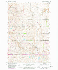
1951 Map of Eldridge NW
USGS Topo · Published 1961About this map
Minneapolis Flats Creek meanders through the central prairie of this Stutsman County landscape, reflecting the glacial topography of the Missouri River Basin. The rail corridor of the Burlington Northern cuts across the southern portion of the sheet, serving as a primary transit artery for the surrounding rural townships. The settlement patterns of Windsor and Eldridge are visible, alongside scattered local landmarks like School No 2 and various Gravel Pits that suggest a localized extraction economy. Water dominates the northern and southern edges, from the expansive Deer Lake and Hidden in the north to Adkinson Lake, Moon Lake, and Lippert in the south, illustrating a landscape shaped by numerous prairie potholes and natural basins.
Find a feature on this map
14 named features on this map. Tap any name to fly to it.
Don’t see what you’re looking for? This feature index may not catch every label — zoom into the map to look around manually.
Map Details
Editions of this 1951 Eldridge NW Map
2 editions found
Other maps of this area

1896 · Jamestown
USGS Topo · 1:125,000

1900 · Pingree
USGS Topo · 1:125,000

1900 · Pingree
USGS Topo · 1:62,500

1950 · Buchanan
USGS Topo · 1:24,000

1951 · Eldridge SE
USGS Topo · 1:24,000

1951 · Eldridge NW
USGS Topo · 1:24,000

1952 · Buchanan
USGS Topo · 1:24,000

1952 · Eldridge
USGS Topo · 1:24,000

1952 · Pingree SW
USGS Topo · 1:24,000

1952 · Eldridge SW
USGS Topo · 1:24,000