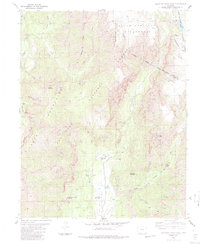
1984 Map of Elephant Head Rock
USGS Topo · Published 1984About this map
The Chalk Mountains define this high-altitude landscape along the border of Archuleta and Conejos counties, where the Continental Divide winds through the South San Juan Wilderness. This area, surveyed in the late 1970s, shows a terrain shaped by water and elevation, from the prominent Elephant Head Rock to the seasonal hydrology of Dustys Meadow. Human activity is concentrated near the Navajo River and its tributaries, where structures like Bond House and Upper Camp sit amidst a network of pack trails and jeep tracks.
Find a feature on this map
43 named features on this map. Tap any name to fly to it.
Don’t see what you’re looking for? This feature index may not catch every label — zoom into the map to look around manually.
Map Details
Editions of this 1984 Elephant Head Rock Map
4 editions found
Other maps of this area

1913 · Summitville
USGS Topo · 1:125,000

1915 · Summitville
USGS Topo · 1:125,000

1945 · Durango
USGS Topo · 1:250,000

1953 · Durango
USGS Topo · 1:250,000

1954 · Durango
USGS Topo · 1:250,000

1957 · Chromo
USGS Topo · 1:62,500

1957 · Wolf Creek Pass
USGS Topo · 1:62,500

1957 · Chama Peak
USGS Topo · 1:62,500

1961 · Durango
USGS Topo · 1:250,000

1963 · Durango
USGS Topo · 1:250,000