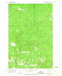
1965 Map of Elevation Mountain
USGS Topo · Published 1967About this map
Mining settlements and high-altitude mountain camps define this mid-1960s survey of the Garnet Range. The map centers on the historic mining district of Garnet, showing the concentration of lode and placer claims that once drove the local economy. To the south, the older camp of Beartown is situated along the creek bottom, providing a clear record of the early mining geography that spanned from the gulches up to the high ridges.
Find a feature on this map
6 named features on this map. Tap any name to fly to it.
Don’t see what you’re looking for? This feature index may not catch every label — zoom into the map to look around manually.
Map Details
Editions of this 1965 Elevation Mountain Map
4 editions found
Other maps of this area

1919 · Drummond
USGS Topo · 1:125,000

1921 · Drummond
USGS Topo · 1:125,000

1947 · Butte
USGS Topo · 1:250,000

1958 · Butte
USGS Topo · 1:250,000

1958 · Drummond
USGS Topo · 1:62,500

1959 · Bearmouth
USGS Topo · 1:62,500

1960 · Butte
USGS Topo · 1:250,000

1962 · Butte
USGS Topo · 1:250,000

1965 · Union Peak
USGS Topo · 1:24,000

1965 · Wild Horse Parks
USGS Topo · 1:24,000