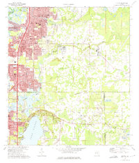
1974 Map of Elfers
USGS Topo · Published 1975About this map
New Port Richey and Tarpon Springs anchor this coastal survey, showing the mid-1970s transition of the West Florida shoreline into a densely developed residential corridor. The expansion of Holiday and Elfers is evident, while the northern reaches of Lake Tarpon remain bordered by Anderson Park and several local burial grounds like Cycadia Cem and Rose Hill Cem. The transportation network is defined by the Seaboard Coast Line and its corresponding railroad grade, which cuts through the flat terrain toward Seven Springs. This era captures the landscape as it shifted from rural sloughs and bayous toward a suburban identity, evidenced by the cluster of churches such as St Vincent De Paul Ch and the West Pasco Airpark on the eastern edge. Natural features like Baileys Bluff and the Pithlachascotee River provide a contrast to the emerging grids of Gulf Harbors.
Find a feature on this map
73 named features on this map. Tap any name to fly to it.
Don’t see what you’re looking for? This feature index may not catch every label — zoom into the map to look around manually.
Map Details
Editions of this 1974 Elfers Map
2 editions found
Other maps of this area

1943 · Dunedin
USGS Topo · 1:31,680

1943 · Tarpon Springs
USGS Topo · 1:31,680

1943 · Odessa
USGS Topo · 1:24,000

1943 · Elfers
USGS Topo · 1:24,000

1943 · Oldsmar
USGS Topo · 1:24,000

1944 · Elfers
USGS Topo · 1:31,680

1944 · Oldsmar
USGS Topo · 1:31,680

1944 · Odessa
USGS Topo · 1:31,680
1947 · Citrus Park
USGS Topo · 1:24,000

1948 · Elfers
USGS Topo · 1:25,000