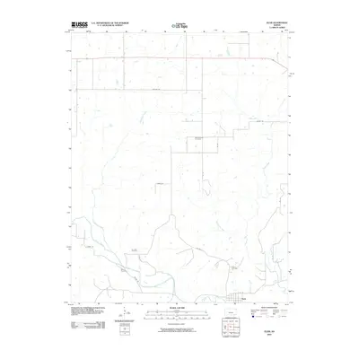
2010 Map of Elgin
USGS Topo · Published 2010About this map
Moore Prairie Cemetery sits centrally in this southern Kansas landscape, marking a rural district defined by the winding course of the Caney River. The settlement of Elgin occupies the southeastern corner of the map, situated just north of the river's path and served by a local road network including E Co Rd and Rd 17. The terrain is deeply etched by a complex drainage system featuring Sycamore Creek and Cedar Creek, which feed into the river valley. For genealogists and local historians, the distribution of burial grounds such as De Busk Cemetery, Wilson Cemetery, and the Elgin Cemetery provides a clear view of early community centers and family clusters in Chautauqua County. The map details a transition from the upland prairies accessed via Heritage Rd down to the bottomlands where the river and its tributaries converge.
Find a feature on this map
21 named features on this map. Tap any name to fly to it.
Don’t see what you’re looking for? This feature index may not catch every label — zoom into the map to look around manually.
Map Details
Editions of this 2010 Elgin Map
This is the sole edition of this map. No revisions or reprints were ever made.
Other maps of this area

1885 · Sedan
USGS Topo · 1:125,000

1889 · Sedan
USGS Topo · 1:125,000

1909 · Pawhuska
USGS Topo · 1:125,000

1910 · Pawhuska
USGS Topo · 1:125,000

1955 · Wichita
USGS Topo · 1:250,000

1955 · Enid
USGS Topo · 1:250,000

1958 · Enid
USGS Topo · 1:250,000

1958 · Wichita
USGS Topo · 1:250,000

1962 · Sedan
USGS Topo · 1:24,000
1962 · Cedar Vale East
USGS Topo · 1:24,000