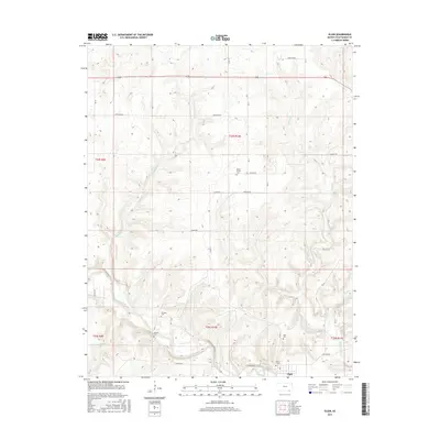
2015 Map of Elgin
USGS Topo · Published 2015About this map
The Caney River winds through the southern reaches of Chautauqua County, anchoring the town of Elgin near the Oklahoma border. This survey illustrates a landscape defined by its riparian network, where Sycamore Cr and Buzzard Cr feed into the primary river valley. For those tracing family histories, the map identifies several local burial sites, including Elgin Cem, Wilson Cem, and De Bask Cem, along with the District 1 Cem and Moore Prairie Cem. The road network is heavily influenced by the Public Land Survey System, with routes like Frontier Rd and Heritage Rd following section lines across the prairie. The convergence of Cedar Cr and W Cedar Cr provides a clear view of the drainage patterns that shaped local settlement and agriculture in this portion of southern Kansas.
Find a feature on this map
24 named features on this map. Tap any name to fly to it.
Don’t see what you’re looking for? This feature index may not catch every label — zoom into the map to look around manually.
Map Details
Editions of this 2015 Elgin Map
This is the sole edition of this map. No revisions or reprints were ever made.
Other maps of this area

1885 · Sedan
USGS Topo · 1:125,000

1889 · Sedan
USGS Topo · 1:125,000

1909 · Pawhuska
USGS Topo · 1:125,000

1910 · Pawhuska
USGS Topo · 1:125,000

1955 · Wichita
USGS Topo · 1:250,000

1955 · Enid
USGS Topo · 1:250,000

1958 · Enid
USGS Topo · 1:250,000

1958 · Wichita
USGS Topo · 1:250,000

1962 · Sedan
USGS Topo · 1:24,000
1962 · Cedar Vale East
USGS Topo · 1:24,000