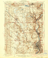
1925 Map of Elgin
USGS Topo · Published 1942About this map
The Fox River corridor anchors this pre-war landscape, showing the industrial and residential growth of Elgin and the neighboring villages of East Dundee and West Dundee before the massive expansion of the Chicago suburbs. This era is characterized by a dense network of rural infrastructure, where nearly every township section is served by a local schoolhouse, such as the Munshawville School and Hickory Grove School. These small rural hubs supported a farming economy linked to the larger world by a complex rail system.
Find a feature on this map
78 named features on this map. Tap any name to fly to it.
Don’t see what you’re looking for? This feature index may not catch every label — zoom into the map to look around manually.
Map Details
Editions of this 1925 Elgin Map
4 editions found
Other maps of this area

1908 · Wheaton
USGS Topo · 1:62,500

1920 · Grays Lake
USGS Topo · 1:62,500

1923 · Grays Lake
USGS Topo · 1:62,500

1923 · Barrington
USGS Topo · 1:62,500

1925 · Elgin
USGS Topo · 1:62,500

1926 · Mc Henry
USGS Topo · 1:62,500

1932 · Harvard
USGS Topo · 1:48,000

1932 · Geneva
USGS Topo · 1:62,500

1935 · Barrington
USGS Topo · 1:62,500

1937 · Sycamore
USGS Topo · 1:62,500