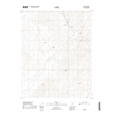
2018 Map of Elgin
USGS Topo · Published 2018About this map
Elgin serves as the focal point of this Lincoln County survey, situated at the confluence of several prominent geographic features. The settlement is located where Rainbow Canyon and Meadow Valley Wash converge, a corridor historically critical for movement through the high desert. To the south, the Meadow Valley Mountains dominate the landscape, while the topography to the west is defined by the Kane Springs Valley and its corresponding drainage, Kane Springs Wash. The importance of water management in this arid environment is evidenced by the Elgin Summit Reservoir, located near the topographic divide. Further north, the landscape levels out into Ash Flat and is cut by numerous deep drainages including Deadman Canyon and Pennsylvania Canyon, illustrating the complex erosional patterns of the region.
Find a feature on this map
15 named features on this map. Tap any name to fly to it.
Don’t see what you’re looking for? This feature index may not catch every label — zoom into the map to look around manually.
Map Details
Editions of this 2018 Elgin Map
This is the sole edition of this map. No revisions or reprints were ever made.
Other maps of this area

1885 · Pioche
USGS Topo · 1:250,000

1886 · Pioche
USGS Topo · 1:250,000

1954 · Caliente
USGS Topo · 1:250,000

1959 · Caliente
USGS Topo · 1:250,000

1969 · Vigo NW
USGS Topo · 1:24,000

1969 · Elgin
USGS Topo · 1:24,000

1969 · Elgin NE
USGS Topo · 1:24,000

1969 · Slidy Mountain
USGS Topo · 1:24,000
1969 · Vigo NE
USGS Topo · 1:24,000

1969 · Elgin SW
USGS Topo · 1:24,000